November 13: India’s Cabinet has approved an 8.449-kilometre extension of Noida Metro’s Aqua Line from Sector 51 to Greater Noida Sector 4, according to the Ministry of Housing and Urban Affairs. Its November 11 announcement specifies five elevated stations and an interchange with the Delhi Metro Blue Line at Noida Sector 61.
Key highlights
- Cabinet approval covers 8.449 km between Noida Sector 51 and Greater Noida Sector 4.
- Five elevated stations and a Sector 61 Blue Line interchange are envisaged.
- Approval does not mean that passenger services have started.
What the Cabinet has cleared
For Greater Noida West residents, the important development is a cleared connection towards the existing rail network. However, an approved corridor and an operating service are different milestones. The announcement should not be read as an instruction to change a journey today.
Why some official maps show a longer route
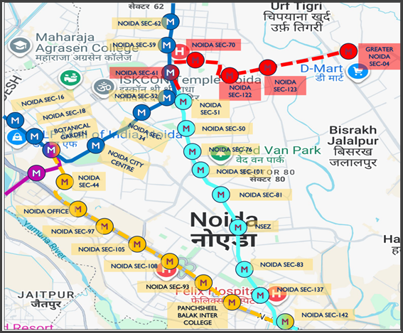
NMRC’s upcoming-projects page describes a broader Sector 51–Knowledge Park V extension of 17.435 km with 11 elevated stations. That page also identifies Sector 61 as the planned Blue Line interchange and names Vikas Marg and the Noida–Greater Noida Link Road as the corridors to be served.
These figures describe different project scopes. The 8.449-km, five-station Cabinet decision should not be presented as approval of every station on the longer Knowledge Park V proposal. Readers comparing maps should first check the endpoints and the date of the document.
NMRC’s page carries an August 10, 2026 update date, preceding the Cabinet announcement. That makes the later ministry release the reference for what was specifically approved this week, while the operator’s page supplies broader planning context.
What an interchange can change
An interchange matters because the usefulness of a new line depends on the journeys it connects, rather than track length alone. For a commuter, a shorter road trip to a station can be offset by an awkward transfer or a long wait. Station access, pedestrian connections and service frequency will therefore matter alongside the route itself.
The ministry expects the extension to improve access to residential and commercial areas, including Gaur City and nearby employment centres. Those are projected benefits, not measured travel-time savings from a line already in service. This report does not attach a guaranteed journey-time reduction to the approval.
What passengers should watch next
The practical milestones are construction progress, updated station details, interchange arrangements and the operator’s eventual passenger-service announcement. A route graphic cannot establish an opening date, train frequency or fare. Those require separate operational information.
Residents considering a future commute should distinguish a nearby station from a convenient walking route to its entrance. Road crossings, feeder transport and access for people with reduced mobility can determine whether a rail connection works in everyday use. Those questions remain worth following as implementation becomes more detailed.
The takeaway for Noida and Greater Noida West
The Cabinet decision advances a specific corridor. It does not make every proposal on a regional metro map operational or approved in the same form. Keep the five-station decision separate from the longer planning page, and use current NMRC passenger information for travel that is taking place now.
At a glance
| Approved endpoints | Noida Sector 51–Greater Noida Sector 4 |
| Length in Cabinet release | 8.449 km |
| Station type and count | Five elevated stations |
| Planned interchange | Noida Sector 61; Delhi Metro Blue Line |
| Status described here | Cabinet approval, not opening of service |
Representational image: Route illustration accompanying the Ministry of Housing and Urban Affairs’ November 11, 2026 release, via PIB / Government of India. The proposed extension is not yet an operational passenger route. Original map labels retained.
Sources
- Ministry of Housing and Urban Affairs / PIB: Cabinet approves Aqua Line extension
- NMRC: Upcoming projects — Aqua Line extensions

The National Desk covers India's politics, governance, security and public-interest news. Stories are checked against at least two credible sources before publication.