October 22: Super Typhoon Champi is moving toward waters east of Taiwan as transport operators around Japan’s southern islands face disruption. The Hong Kong Observatory’s 10 am bulletin on Thursday placed the storm at 20.3°N, 126.0°E at 8 am Hong Kong time, with maximum sustained winds near its centre of 210 km/h. Forecast positions are not confirmed landfall locations.
Key highlights
- The latest observation cited here is 8 am HKT on October 22, not a live tracker.
- The Hong Kong Observatory expects Champi to move toward seas east of Taiwan today and tomorrow.
- Weathernews identified risks to maritime routes near Taiwan and the Sakishima Islands.
- Reported flight and ferry disruptions require checks against each operator’s latest notice.
What the official bulletin shows
The Observatory’s October 22 bulletin classified Champi as a super typhoon. Its forecast showed the system at 22.8°N, 124.0°E at 8 am HKT on October 23, with winds near the centre forecast at 175 km/h. The subsequent forecast positions indicated further weakening.
The agency also warns that track uncertainty increases over time and that short-term departures from the expected course can occur. Those caveats matter for readers comparing maps: an island close to a forecast line is not necessarily the only place exposed to difficult weather.
Observation and forecast: keep them separate
| Indicator | Latest position |
|---|---|
| Observed, October 22, 8 am HKT | 20.3°N, 126.0°E; 210 km/h near the centre |
| Forecast, October 23, 8 am HKT | 22.8°N, 124.0°E; 175 km/h |
| Forecast, October 24, 8 am HKT | 26.2°N, 123.3°E; 140 km/h |
| Source and issue time | Hong Kong Observatory, 10 am HKT on October 22 |
The table reproduces one agency’s dated assessment. The future rows should not be compared with historical measurements as if all three have already happened. This report does not establish a precise landfall point or a local wind speed for an individual airport.
Why the Taiwan–Okinawa corridor matters
In its October 21 marine assessment, Weathernews described Champi as a large, violent system affecting passages near Taiwan and the southern Ryukyu Islands. It warned of hazards to vessels, ports and offshore infrastructure through the approach period.
Its outlook anticipated a northward turn and a weakening trend as the storm moved into less favourable conditions. That forecast is older than the Observatory observation above and uses its own presentation of wind measurements. We have not combined the two into a new, supposedly official forecast.
Flights and ferries: check the whole journey
The Economic Times reported that Japan Airlines had listed weather-related cancellations affecting Okinawa-area destinations through October 24. It also reported that Anei Kanko planned to cancel all routes and sailings on October 22 and 23, with later service dependent on conditions.
Those are operator arrangements reported on October 21, not a guarantee that every flight remains cancelled or every later sailing will resume. Passengers should check their flight number and the ferry route separately before leaving. A flight operating to an island does not establish that an onward ferry connection is available.
When a journey includes separate tickets, keep the confirmation numbers and contact details for each operator available. Rebooking and refund eligibility depend on the ticket and the operator’s arrangements; this report does not promise automatic compensation.
What to watch
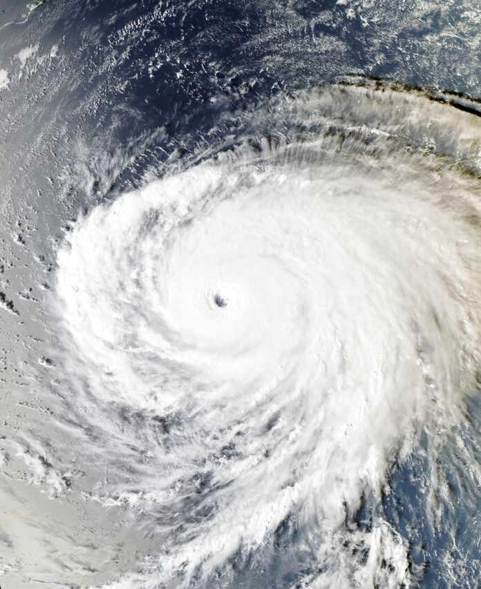
Follow updated official bulletins and local notices as Champi approaches. Travellers should use current airline and ferry service-status pages rather than an old map or a screenshot without a time stamp. The featured satellite image is dated October 20 and is clearly identified as a file image, not today’s live view.
Featured image: MODIS / Aqua, NASA EOSDIS Worldview / Wikimedia Commons, public domain. Displayed with responsive cropping.
Sources
- Hong Kong Observatory: Tropical Cyclone Position, bulletin checked October 22
- Weathernews: Champi reaches peak intensity, tracking toward Taiwan and Sakishima
- The Economic Times: Typhoon Champi disrupts Japan travel

The International Desk covers world and Asian affairs, diplomacy and conflict, with a focus on what they mean for India. Stories are checked against at least two credible sources before publication.