October 23: The World Meteorological Organization has warned that the ongoing El Niño could reach exceptional strength toward the end of 2026, with Southeast Asia facing increased heat and rainfall-deficit risks. Its October 21 statement urges governments and humanitarian agencies to act before seasonal hazards become emergencies.
Key highlights
- WMO expects the event to peak toward the end of 2026, with consequences potentially lasting longer.
- Southeast Asia faces warmer conditions and rainfall deficits, with implications for farms, water supplies and haze.
- A seasonal outlook is not a forecast of a particular local disaster.
- Food-security effects can arrive after the weather shock, according to FEWS NET.
What the new warning says
In her October 21 briefing, WMO Secretary-General Celeste Saulo said tropical Pacific sea-surface temperatures could be 3.8°C above average during November 2026–January 2027. This refers to ocean temperatures in the forecast region, not an expected rise in every country’s air temperature. WMO stresses that national and regional forecasts remain essential.
The agency specifically identified additional pressure on Southeast Asian agriculture and water supplies, together with wildfire and smoke-haze risk. It did not predict a named fire, a precise city-level pollution reading or a fixed loss of harvests. Those distinctions matter when interpreting an alarming global headline.
Why food impacts may come later
FEWS NET’s October 6 special report separates the timing of unusual rainfall from the timing of acute food insecurity. A failed rainy season can first affect planting and crops, then household stocks and incomes. Assistance needs can therefore remain elevated after ocean conditions begin to weaken.
Its regional assessment assigns high concern to Southern Africa, where forecasts point to a late rainy-season start, dry spells and heat. These are regional findings, not a basis for assuming identical conditions in Asian countries. Local crop calendars, irrigation and existing household vulnerability affect how a climate shock translates into hardship.
At a glance: reading the warning correctly
| Signal | What it supports | What it cannot establish |
|---|---|---|
| Pacific ocean warming | A major seasonal climate driver | Each city warming by the same amount |
| Southeast Asian rainfall deficits | Closer monitoring of water and agriculture | A guaranteed drought in every district |
| Higher fire and haze risk | Preparedness and air-quality monitoring | A forecast pollution reading for a particular day |
| Food-security concern | Planning across the crop and income cycle | An already measured loss in every country |
Preparedness extends beyond weather alerts
The UN Development Coordination Office’s October 13 analysis describes country teams preparing integrated responses rather than treating El Niño only as a weather event. The issue involves food systems, water, public services and the ability of vulnerable communities to recover from successive shocks.
That approach is relevant to Asian readers because a hazard becomes more damaging when it meets existing pressures. A forecast alone does not reveal whether a household has reliable water, savings, a safe workplace or access to assistance. Preparedness should connect climate information with those practical needs, while avoiding unsupported claims about particular communities.
What to watch
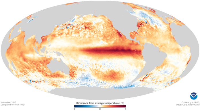
Watch the next national meteorological bulletins, reservoir and agriculture notices, air-quality advisories and local emergency instructions. Businesses should distinguish a seasonal risk assessment from an operational closure notice. Readers should also be wary of old weather maps circulated as current observations: the historical NOAA image used here illustrates an earlier El Niño, not October 2026 conditions.
Representational image: NOAA map of sea-surface temperature anomalies in November 2015, during an earlier El Niño; not a 2026 observation. Credit: NOAA / Wikimedia Commons, public domain. Image source and licence.
Sources
- WMO: El Niño and humanitarian action
- FEWS NET: 2026–2027 El Niño food security impacts
- UN Sustainable Development Group: How UN country teams are advancing integrated responses to El Niño

The International Desk covers world and Asian affairs, diplomacy and conflict, with a focus on what they mean for India. Stories are checked against at least two credible sources before publication.